
CSE : REDC | OTCQB : REDRF


The Company recently discovered large-scale copper porphyry system.
2025 drill program is testing most advanced target at Kendal Ridge. Bulk of 4 km by 3 km system untested.
Excellent infrastructure offers significant advantages to improve margin potential.

Resistivity slice at 200m ASL. Interpreted footprint of Kendal hydrothermal system defined by an extensive zone of relative conductivity
(MMT resistivity low).
New, untested coincident geochemical highs.
Small portion of interpreted hydrothermal system tested.
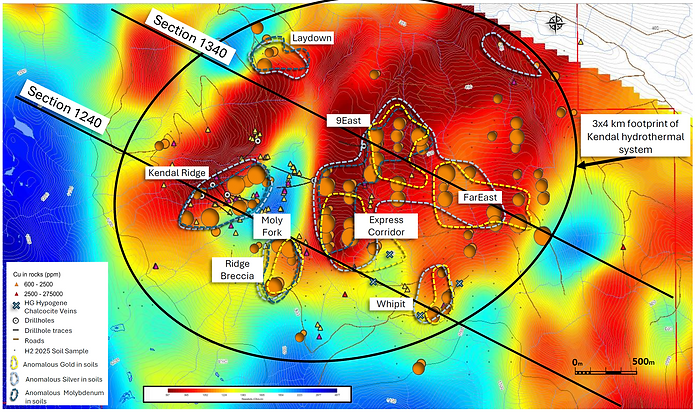
The strongest portion of the resistivity high geophysical feature identified on the Moly Fork trend remains untested.
Area immediately east of Kendal Ridge hosts breccias with copper-molybdenum mineralization and high-grade hypogene chalcocite veining with select grades of up to 27.5% copper.


Areas with high resistivity and subdued magnetic responses within the Kendal Ridge zone appear closely associated with altered porphyry intrusions, hosting multiple generations of complex porphyry-style veins and variable alteration.
RCKD-25-006 NQ drill hole showing an altered porphyry intrusion and associated B-style veins.

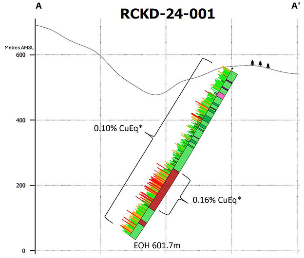

RCKD-24-001 at Kendal returned 0.10% CuEq* from surface to 601.7 m depth, including 123.0 m grading 0.16% CuEq*


